Lakesidetrader - Top
Display your banner here
Page 1 of 9 1 2 3 4 5 ... LastLast
Results 1 to 10 of 83

Geography of the USSR. Kiev under the german occupation

Article about: Kiev (in Russian: Київ) It is the capital and the largest city of Ukraine. Administrative capital of the Kiev Oblast. Crossed by the Dnieper River Its population in 1

  1. #1

    Default Geography of the USSR. Kiev under the german occupation

    Kiev (in Russian: Київ)
    It is the capital and the largest city of Ukraine.
    Administrative capital of the Kiev Oblast.
    Crossed by the Dnieper River
    Its population in 1940 was 930,000 inhabitants.
    Located 850 kilometers southwest of Moscow.
    Conquered by the Nazis on September 19, 1941.
    The city was liberated by the Soviets on November 6, 1943.

    PART ONE. THE CONQUEST

    The battle of Kiev was very hard because the Soviets offered a tough resistance to the German invaders.
    The offensive was not progressing at the desired pace. It was thought of strengthening it with a part of the forces of the Army Group Center.
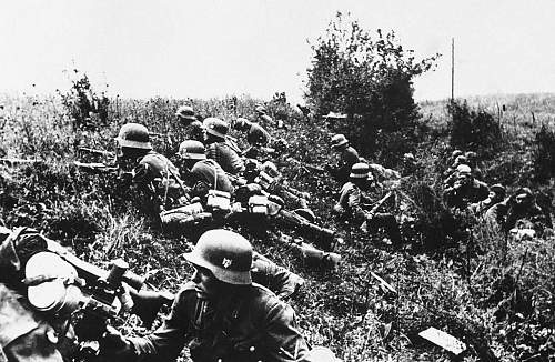
    So the German High Command decided to divert south to the powerful 2nd Panzer Group, under Guderian's command; to encircle the Soviets and eliminate resistance in Kiev.

    Geography of the USSR. Kiev under the german occupation

    Guderian is comming

    Geography of the USSR. Kiev under the german occupation

    German troops near the city

    Geography of the USSR. Kiev under the german occupation

    Kiev encirclement

    Geography of the USSR. Kiev under the german occupation

    German avant-garde with Kiev in the distance

  2. # ADS
    Circuit advertisement Geography of the USSR. Kiev under the german occupation
    Join Date
    Always
    Location
    Advertising world
    Age
    2010
    P
    Many
     

  3. #2

    Default

    Geography of the USSR. Kiev under the german occupation

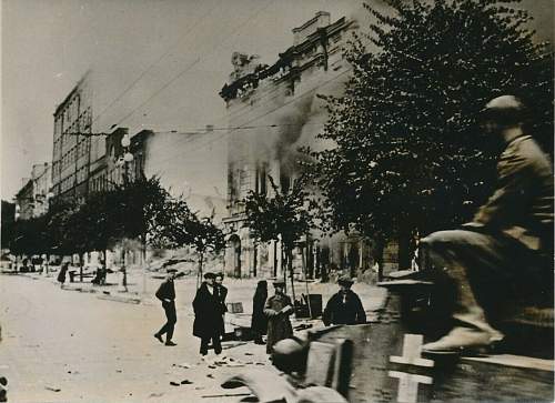
    Podolsky District. German gunners bombing a barricade on Vyshgorodskaya street.

    Geography of the USSR. Kiev under the german occupation

    Another image of the same place already cleared of defenders by the Germans.

    Geography of the USSR. Kiev under the german occupation

    Going along Kirova Street.

    Geography of the USSR. Kiev under the german occupation

    The assault troops arrive in the vicinity of the Monastery of Lavra.

    Geography of the USSR. Kiev under the german occupation

    Objective achieved A group of Germans photographed at the gates of the Lavra Monastery.

    Geography of the USSR. Kiev under the german occupation

    Geography of the USSR. Kiev under the german occupation

    A Press agency photograph of September 23, 1941.

    "Armored vehicles roll over a conquered Kiev.
    After the hard fighting the German flag flies in the city of Kiev.
    Our photo shows one of the first German tanks entering the city to clean it of Russian soldiers who could have stayed there.
    Once again the Russians have burned outside the city".
    Last edited by TabsTabs1964; 10-10-2019 at 06:12 PM.

  4. #3

    Default

    The next thing is to climb to the top of the bell tower of the Monastery church and contemplate the Dnieper in the distance.

    Geography of the USSR. Kiev under the german occupation

    A German sentry at the top of the bell tower.

    Geography of the USSR. Kiev under the german occupation

    Kiev from the fourth level of the bell tower of Pechersk Lavra.

    Geography of the USSR. Kiev under the german occupation

    In the background the Navodnitsky bridge burns.

    Geography of the USSR. Kiev under the german occupation

    A German soldier admiring a bell.

  5. #4

    Default

    The feeling of victory must have invaded every German soldier, although the wear suffered by the Germans, would end up being noticed in the following offensives.

    Geography of the USSR. Kiev under the german occupation

    Geography of the USSR. Kiev under the german occupation

    Around 665,000 Soviet soldiers were captured in the pocket of Kiev.

    To be continue.

  6. #5

    Default

    Thanks for the great pics. Just finished the book Kiev 1941 by David Stahel. Great book on the battle in my opinion. Incredible amount of prisoners taken. Unfortunately many were to perish by the following February according to the author.

  7. #6

    Default

    PART TWO. THE RIVERS AND THE BRIDGES.

    The mighty Dnieper River runs through the city of Kiev from North to South. In addition, the Desná River (which is its tributary) flows into the right bank of the Dnieper just north of the city.

    Geography of the USSR. Kiev under the german occupation

    Both rivers are a natural barrier, a major obstacle, for the advance of the German army to the east.

    Geography of the USSR. Kiev under the german occupation

    Viewpoint on the Dnieper. From this picturesque place the German soldiers took pictures of the great river

    Geography of the USSR. Kiev under the german occupation

  8. #7

    Default

    Geography of the USSR. Kiev under the german occupation
    tabstabs collection

    Russian pioneers dynamited all the bridges over the two rivers during the retreat.

    Geography of the USSR. Kiev under the german occupation

    The first german troops crossed the Dnieper in pneumatic boats.

    The Germans had units of engineers specialized in the construction of pontoon bridges. In Kiev they had the opportunity to demonstrate their expertise.

    Geography of the USSR. Kiev under the german occupation

    Another image of the main bridge over the Dnieper. Totally destroyed.

    Geography of the USSR. Kiev under the german occupation

    So the Germans had to build a large pontoon bridge.

  9. #8

    Default

    Geography of the USSR. Kiev under the german occupation

    Very soon a new bridge crossed the Dnieper.

    Geography of the USSR. Kiev under the german occupation

    But other crossing means were needed. Ferry Pier.

    Geography of the USSR. Kiev under the german occupation

    Two German soldiers on the ferry dock meet the Lavra Monastery on the other side of the river.

    Geography of the USSR. Kiev under the german occupation
    tabstabs collection

    Sailing aboard the ferry. The same landscape in the background

    Geography of the USSR. Kiev under the german occupation

    Geography of the USSR. Kiev under the german occupation

    Above two images of the trimaran that crossed between both banks of the river.

  10. #9

    Default

    Geography of the USSR. Kiev under the german occupation

    Geography of the USSR. Kiev under the german occupation

    Several bridges had to be built.

    Geography of the USSR. Kiev under the german occupation

    Geography of the USSR. Kiev under the german occupation

    And the soldiers took pictures with the monastery in the background.

    Geography of the USSR. Kiev under the german occupation

    Geography of the USSR. Kiev under the german occupation

    "Kriegsbrücke bei Kiew" or "Vormarsch über Dnepr" wrote the German soldiers on the reverse side of the photographs they send home.

    Geography of the USSR. Kiev under the german occupation

    Geography of the USSR. Kiev under the german occupation

    Geography of the USSR. Kiev under the german occupation

    There were also other piers, like this.

    Geography of the USSR. Kiev under the german occupation
    tabstabs collection

    This German officer is photographed while he photographs the monastery on the opposite shore.

    On the back of the photo, it is written in pencil: Floßbrücke bei Kiew, Dnjepr, 1942.

  11. #10

    Default

    Geography of the USSR. Kiev under the german occupation

    Geography of the USSR. Kiev under the german occupation
    tabstabs collection

    German engineers also had to build several bridges to cross the Desná River, somewhat north of Kiev.

    Geography of the USSR. Kiev under the german occupation

    Album of a German soldier with his photographs on the subject.

    With the lines of communication open, the Wehrmacht's progress towards the east could continue.
    And the occupants had to start worrying about organizing the occupation of the great conquered city

    To be continue

Page 1 of 9 1 2 3 4 5 ... LastLast

Similar Threads

  1. Geography of the USSR. Kharkov under the german occupation

    In History and Research Third Reich and WW2
    11-10-2023, 08:25 PM
  2. Geography of the USSR. Minsk under the german occupation

    In History and Research Third Reich and WW2
    11-10-2023, 08:04 PM
  3. Geography of the USSR. Orel under german occupation

    In History and Research Third Reich and WW2
    11-10-2023, 07:54 PM
  4. 12-29-2013, 08:00 PM
  5. The last German field car left in Jersey from the German occupation.

    In Field Equipment And Accessories of the Third Reich
    10-29-2011, 05:42 PM

Bookmarks

Posting Permissions

  • You may not post new threads
  • You may not post replies
  • You may not post attachments
  • You may not edit your posts
  •  
Militaria-Reisig & Antiquitäten - Down
Display your banner here