Great Militaria - Top
Display your banner here
Page 11 of 21 FirstFirst ... 7 8 9 10 11 12 13 14 15 ... LastLast
Results 101 to 110 of 205

Geography of the USSR. Smolensk under the german occupation

Article about: Smolensk (Russian: Смоленск). City in western Russia, it´s the administrative capital of the Smolensk Oblast, on the banks of the upper course of Dnieper River. Its population in 19

  1. #101

    Default

    Geography of the USSR. Smolensk under the german occupation

    "Kranwagen vor der Narwa-Kaserne". Crane truck in front of Narva Barracks

    Geography of the USSR. Smolensk under the german occupation

    Have you noticed what these soldiers are seeing between several intact buildings?

    A soccer game !!

    Geography of the USSR. Smolensk under the german occupation

    This other building is next to the wall.

    Geography of the USSR. Smolensk under the german occupation

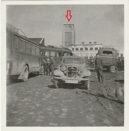
    Look at the tower

    Geography of the USSR. Smolensk under the german occupation

    Virtually any intact building was occupied by some service of the Germans

  2. # ADS
    Circuit advertisement Geography of the USSR. Smolensk under the german occupation
    Join Date
    Always
    Location
    Advertising world
    Age
    2010
    P
    Many
     

  3. #102

    Default

    Geography of the USSR. Smolensk under the german occupation

    Geography of the USSR. Smolensk under the german occupation
    Distillery building

    Geography of the USSR. Smolensk under the german occupation
    In ruins after the battle

    Geography of the USSR. Smolensk under the german occupation

    Geography of the USSR. Smolensk under the german occupation

    This tall structure, perhaps a grain warehouse, was near the railway station in the Zadneprovie district, in the northern part of the city.

    Geography of the USSR. Smolensk under the german occupation

    Geography of the USSR. Smolensk under the german occupation

    Geography of the USSR. Smolensk under the german occupation

    Geography of the USSR. Smolensk under the german occupation

    Geography of the USSR. Smolensk under the german occupation

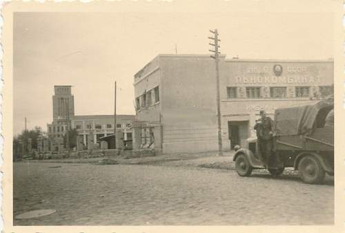
    Again the same tower. The sign in the nearest building says Linokombinat: Linen Mill

    Geography of the USSR. Smolensk under the german occupation

    Kolkhoz Square
    Last edited by TabsTabs1964; 11-21-2020 at 07:33 PM.

  4. #103

    Default

    Another important building was the so called "House of the Specialists", built between 1934 and 1936 as a residential building for the technical and creative intelligentsia of the region. In this case, the building suffered significant damage.

    Geography of the USSR. Smolensk under the german occupation

    Geography of the USSR. Smolensk under the german occupation

    Geography of the USSR. Smolensk under the german occupation

    Geography of the USSR. Smolensk under the german occupation

    Geography of the USSR. Smolensk under the german occupation

    Geography of the USSR. Smolensk under the german occupation

    Geography of the USSR. Smolensk under the german occupation

    Russian POWs in front this building

    It was a building with 76 apartments with a shopping area on the ground floor, south of the city occupying a whole block along Gagarin Avenue. On its pediment there is an inscription "House of specialists"

    It was restored in the 50s
    Last edited by TabsTabs1964; 11-22-2020 at 08:37 AM.

  5. #104

    Default The Teapot

    There was another curious building that caught the attention of the German soldiers and was photographed extensively. Its silhouette stood out clearly in the smolensk sky line.

    The Commune House or simply "Teapot" was Smolensk's first skyscraper, construction of which began in the pre-war years. It was a truly unheard of structure for the city. Seven floors towering over low wooden buildings.

    Geography of the USSR. Smolensk under the german occupation

    Geography of the USSR. Smolensk under the german occupation

    Geography of the USSR. Smolensk under the german occupation

    Geography of the USSR. Smolensk under the german occupation

    Geography of the USSR. Smolensk under the german occupation

    Geography of the USSR. Smolensk under the german occupation

    Very close to the Monastery of the Ascension and visually making a triangle with the cathedral somewhat further away

    Geography of the USSR. Smolensk under the german occupation

    The monastery of the Ascensión, near to the Teapot building

  6. #105

    Default

    Its interior structure was not common either. No elevator and no corridors. Water supply only on the ground floor. Shared bathrooms in the basement.

    Geography of the USSR. Smolensk under the german occupation

    Building plan

    On the ground floor, a kindergarten and a kitchen for the little residents of the house.

    The rooms in the longhouse were very narrow: 8-12 square meters. As conceived by the creators, all the inhabitants of the building had to live as a common family, united by a desire to benefit the country and dispersed to their rooms only at night.

    Geography of the USSR. Smolensk under the german occupation

    Geography of the USSR. Smolensk under the german occupation
    tabstabs collection

    Geography of the USSR. Smolensk under the german occupation

    However, these plans did not come true: the war began and the building was badly damaged. After the war it was a temporary shelter, it was left empty after a fire in the mid-70s.

  7. #106

    Default

    Geography of the USSR. Smolensk under the german occupation

    A view of the cathedral from the top of the Teapot building

    Geography of the USSR. Smolensk under the german occupation

    Geography of the USSR. Smolensk under the german occupation

    Two current images. In color and black and white.

    Geography of the USSR. Smolensk under the german occupation

    Geography of the USSR. Smolensk under the german occupation

    The building is still there, at the top of the hill.

  8. #107

    Default

    Quote by toot View Post
    you have gotton this guy sold on the site. I cannot wait for them to come in. you should make them into a book! I would be the first in in line for one!!
    I'd be in for a book too, only one I have comparable is Paul Carell's "Operation Barbarossa the war in Russia as photographed by the soldiers"

  9. #108

    Default

    Thanks for your kind words Rene, and also for the comparison!

    I was unfamiliar with Paul Carell's book and just bought the German edition on ebay.de for very little money.

    Geography of the USSR. Smolensk under the german occupation

    Thanks twice, buddy.

    Cheers!! and keep safe Down Under!!

    Santi
    Last edited by TabsTabs1964; 11-15-2020 at 01:46 PM.

  10. #109

    Default

    No probs and you WILL enjoy the book

  11. #110

    Default The Hauptstrasse

    Bolshaya Sovetskaya Street. It is one of the oldest and most important streets in Smolensk, descending from the central part of the city to the central bridge over the Dnieper and passing in front of the symbol of the city, the Cathedral of the Assumption, which towers over its own hill.

    Geography of the USSR. Smolensk under the german occupation

    The Germans called it the Hauptstrasse (the Main Street) It was the road that linked the avenues in the south of the city with the railway station in the northern district.

    Geography of the USSR. Smolensk under the german occupation

    Vehicle traffic was constant on that avenue.

    Geography of the USSR. Smolensk under the german occupation

    Picture taken at the intersection of Bolshaya Sovetskaya and Leninskaya streets
    Last edited by TabsTabs1964; 11-22-2020 at 08:39 AM.

Page 11 of 21 FirstFirst ... 7 8 9 10 11 12 13 14 15 ... LastLast

Similar Threads

  1. Geography of the USSR. Kharkov under the german occupation

    In History and Research Third Reich and WW2
    11-10-2023, 08:25 PM
  2. Geography of the USSR. Minsk under the german occupation

    In History and Research Third Reich and WW2
    11-10-2023, 08:04 PM
  3. Geography of the USSR. Kiev under the german occupation

    In History and Research Third Reich and WW2
    11-10-2023, 07:58 PM
  4. Geography of the USSR. Orel under german occupation

    In History and Research Third Reich and WW2
    11-10-2023, 07:54 PM
  5. Geography of the USSR: The Ass of the World.

    In History and Research Third Reich and WW2
    11-10-2023, 07:53 PM

Bookmarks

Posting Permissions

  • You may not post new threads
  • You may not post replies
  • You may not post attachments
  • You may not edit your posts
  •  
MilitaryHarbor - Down
Display your banner here