-
 Geography of the USSR. Smolensk under the german occupation
Smolensk (Russian: Смоленск).
City in western Russia, it´s the administrative capital of the Smolensk Oblast, on the banks of the upper course of Dnieper River.
Its population in 1939 was 157,000 inhabitants (351,000 today).
Located 360 kilometers southwest of Moscow.
It was on the invasion routes of Napoleon and Hitler.
Conquered by the Germans in July 1941.
The city was liberated in October 1943.

I have collected about three hundred photographs and maps. Some are well known, many other private photos, and about thirty from my collection, from auctions of private photographs of German soldiers, that no one has ever seen before, except of course, the soldiers who took them during the war.
I hope to share them over the next few weeks and that we enjoy this new illustrated story.
Please feel free to contribute any images or comments that will undoubtedly improve this new thread on geography of the USSR.
Best regards.
Santi

-
10-24-2020 12:53 PM
# ADS
Circuit advertisement

-
Situation prior to the Battle of Smolensk.
After the fall of Minsk on July 3, 1941, with little rest the German Panzer spearheads continued their advance eastward.

A Panzer unit starts the offensive from Vitebsk, about 130 km from Smolensk.

The German assault began, approximately from a North-South line: Vitebsk, Orsha, Mogilev
On July 12, the Stavka ordered Timoshenko to launch a counterattack from the north of Smolensk and Orsha, towards Vitebsk. Six weakened Soviet armies, somewhat uncoordinated, thundered on the Germans.
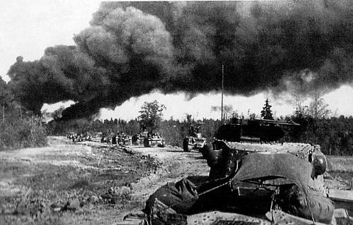
Panzer Divisions are advancing apace, although they inevitably suffer losses.
Guderian and Hoth repelled the Soviet counterattacks, but at a high price. By July 16, the 18th Panzer had twelve operational tanks left.

German troops begin to take prisoners

A Russian sniper captured.... His destiny is written
-
-
-
German War Report. August 5th
German War report.
"Comrades. German troops have today put an end to the Battle of Smolensk, managing to annihilate their pockets, destroying the 16th, 19th and 20th Soviet Armies and capturing more than 300,000 Bolshevik soldiers, 3,200 tanks, 3,100 guns and 1,000 aircraft in what constitutes a catastrophe. of gigantic proportions for the Red Army.
Soviet prisoners of war number in the thousands.


As we have seen, the encirclement of Smolensk was created by General Hoth's 3rd Panzer Group and General Guderian's 2nd Panzer Group as they resumed their advance after the victory of Minsk and headed north and south to surround Smolensk. Smolensk itself, the so-called “gate to Moscow” fell on July 16, and Soviet forces east of the city were surrounded.
At first they were surrounded only by the Panzers who had to wait for the arrival of the infantry.
Last night, the German High Command announced: “the bulk of the Soviet forces encircled east of Moscow has been annihilated. The rest are scattered. "


There is no escape outside the Smolensk pocket for the Bolshevik soldiers, who surrender in waves.
Marshal Timoshenko, commanding several newly formed armies, desperately tried to rescue the surrounded armies, but his attacks suffered from poor preparation and, despite some ruptures, the rescue attempt failed "


Hermann Hoth. North

Heinz Guderian. South

Hitler congratulating von Bock. Borisov- Belarus, August 4, 1941
The drama of the battle is over. Now begins the tragedy of the German occupation of the city that will last until September 25, 1943. Twenty-six months that will cost the lives of tens of thousands of its inhabitants.
-
-
Smolensk has always been Russia's western outpost. For centuries, it was the first to be attacked by Western invaders: Poles, Lithuanians, French (1812) and Germans (1941)
The city is not very large, its population in 1939 was 157,000, but its geographic location is unique, as it is crossed by the strategically important railway and highway that go from Moscow to the western border.
But in addition Smolensk is crossed from east to west by the great Dnieper River. And it´s the river that divides the city into its two parts.

This picture of a "Rotten" of Messerschmitt Bf 109 fliying over Smolensk, allowing us to see how the river divides the city into two parts. To the north the plain and to the south hills on one of which the cathedral stands out.
The northern part of the city that is the smallest, is the Dnieper valley plain and forms the district of Zadneprovie, where the railway station and its facilities, factories and the great market are located and which was the scene of the fighting for the conquest of the city.
The southern part, much larger, is between hills, furrowed by ravines. That is the historical part of Smolensk, where once stood a huge and powerful fortress (the Kremlin) that defended Russia from the west. The fortress has largely survived and the fragments of its walls (built between 1595 and 1602) with towers are still in the central part of the city.

From the plain to the north of the city, you can see across the river, on a hill, the Orthodox Cathedral of the City: the Cathedral of the Assumption (from the late 17th and early 18th centuries) that stands out in the landscape.

Watercolor of the cathedral painted by a German soldier in the spring of 1943
Actually, the German occupiers took a lot of pictures of the city's cathedral.....
-
-
-


Bookmarks